Brazil Geospatial Analytics Market
Brazil Geospatial Analytics Market Size, Share, By Type (Surface Analysis, Network Analysis, Geovisualization), By End Use Industry (Agriculture, Utility and Communication, Defense and Intelligence, Government, Mining and Natural Resources, Automotive and Transportation, Healthcare, Real Estate and Construction, and Others), Brazil Geospatial Analytics Market Insights, Industry Trend, Forecasts to 2035
REPORT COVERAGE
Country
Brazil Geospatial Analytics Market Size Insights Forecasts to 2035
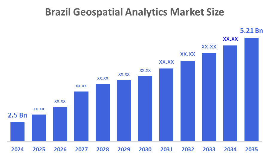
- Brazil Geospatial Analytics Market Size 2024: USD 2.5 Bn
- Brazil Geospatial Analytics Market Size 2035: USD 5.21 Bn
- Brazil Geospatial Analytics Market CAGR 2024: 6.9%
- Brazil Geospatial Analytics Market Segments: Type and End Use Industry.
Geospatial Analytics Means studying data that is linked to places or locations on the Earth. It helps people understand what is happening where, by using maps, satellite images, and location data. This makes it easier to find patterns, solve problems, and make better decisions in fields like transport, city planning, environment, and business. Furthermore, the Brazil geospatial analytics market is growing due to the rising use of location-based services, government smart city initiatives, expansion of digital infrastructure, increased demand from agriculture and urban planning, and adoption of AI, cloud computing, and satellite data for better decision-making.
The Brazilian government has been actively promoting the adoption of geospatial analytics across various sectors. Initiatives such as the National Plan for Geospatial Information (PING) and the National Geospatial Infrastructure (INDE) aim to enhance the availability, quality, and interoperability of geospatial data. These government-led efforts have created a favorable environment for geospatial analytics adoption and implementation. In addition, the integration of geospatial analytics with emerging technologies, such as big data, the Internet of Things (IoT), artificial intelligence (AI), and machine learning, is driving market growth. These technologies enable the processing, analysis, and visualization of vast amounts of geospatial data, leading to real-time monitoring, predictive analytics, and intelligent decision-making.
The companies operating in the geospatial analytics sector often collaborate with government agencies, research institutions, and industry stakeholders to develop innovative solutions. These partnerships might facilitate knowledge sharing, resource pooling, and the exchange of best practices. Collaborative efforts would promote the advancement of geospatial analytics technologies, enabling companies to deliver more robust and tailored solutions to meet market demands. Moreover, companies involved in geospatial analytics would recognize the importance of continuous research and development to enhance their offerings. With government support, these companies could invest in cutting-edge technologies, explore new data sources, and improve analytical capabilities. This might foster innovation, enable advanced algorithms' development, and drive the market forward. Moreover, according to data from the Ministry of Communications, Government of Brazil, in 2022, the satellites in commercial operation in Brazil are mainly operated by Intelsat License LLC, with around 11 satellites, followed by Embratel TVSAT Telecommunications S.A. with six satellites. The presence of satellite operators like Intelsat License LLC and Embratel TVSAT Telecommunications S.A. indicates the availability of satellite data, which can support geospatial analytics initiatives in Brazil.
Market Dynamics of the Brazil Geospatial Analytics Market:
The Brazil geospatial analytics market is driven by the need to manage large geographic areas efficiently. Growing use of digital maps, satellite images, and location data helps governments and businesses plan cities, monitor forests, improve transport, and support agriculture. Rising urbanization, infrastructure development, disaster management needs, and wider adoption of cloud and data technologies are encouraging organizations to use geospatial analytics for accurate planning, cost control, and faster decision-making across multiple sectors.
The Brazil geospatial analytics market faces restraints such as high implementation and maintenance costs, limited availability of skilled professionals, and data privacy concerns. Inconsistent data quality, lack of standardization, and low awareness among small businesses also slow adoption, especially in rural and underdeveloped regions, reducing the speed of market growth.
The Brazil geospatial analytics market offers strong opportunities through smart city development, expansion of precision agriculture, and growing demand for environmental and climate monitoring. Increasing use of drones, satellites, and real-time location data creates new applications in infrastructure planning, disaster management, and logistics. Adoption of cloud platforms and AI-based analytics also allows small and mid-sized organizations to access geospatial tools at lower costs, opening new growth avenues across both public and private sectors.
Market Segmentation
The Brazil Geospatial Analytics Market share is classified into type and end-use industry.
By Type:
The Brazil Geospatial Analytics market is divided by type into surface analysis, network analysis, and geovisualization. Among these, the geovisualization segment dominated the share in 2024 and is anticipated to grow at a remarkable CAGR during the forecast period. Geovisualization dominates because it allows complex location-based data to be presented in easy-to-understand maps, charts, and dashboards. Government agencies, urban planners, and businesses widely use visual tools for smart city planning, infrastructure development, environmental monitoring, and public safety. These solutions require less technical expertise than advanced analytics, making them more accessible. The growing need for real-time insights and quick decision-making further increases demand for geovisualization across public and private sectors.
By End-Use Industry:
The Brazil Geospatial Analytics market is divided by end-use industry into agriculture, utility and communication, defense and intelligence, government, mining and natural resources, automotive and transportation, healthcare, real estate and construction, and others. Among these, the agriculture segment dominated the share in 2024 and is anticipated to grow at a remarkable CAGR during the forecast period. Agriculture dominates because the country has vast farmland and is one of the world’s largest producers of crops such as soybeans, sugarcane, and corn. Farmers and agribusinesses increasingly use satellite imagery, GPS, and spatial data to monitor crops, manage soil health, predict yields, and reduce risks from weather changes. Government support for digital farming and the need to improve productivity and sustainability further drive strong adoption of geospatial analytics in the agricultural sector.
Competitive Analysis:
The report offers the appropriate analysis of the key organisations/companies involved within the Brazil geospatial analytics market, along with a comparative evaluation primarily based on their product offering, business overviews, geographic presence, enterprise strategies, segment market share, and SWOT analysis. The report also provides an elaborative analysis focusing on the current news and developments of the companies, which includes product development, innovations, joint ventures, partnerships, mergers & acquisitions, strategic alliances, and others. This allows for the evaluation of the overall competition within the market.
Top Key Companies in Brazil Geospatial Analytics Market:
- Esri Brasil
- Google LLC
- Hexagon AB
- Trimble Inc.
- INPE (National Institute for Space Research)
- Bentley Systems
- Autodesk
- Santiago & Cintra
- Imagem Geosistemas
- IBM
- Others
Recent Developments in Brazil Geospatial Analytics Market:
June 2023, PXGEO, a leading marine geophysical company, made an exciting announcement regarding its recent contract with Petrobras. The renowned Brazilian energy corporation has commissioned PXGEO to conduct a cutting-edge 3D ocean bottom node (OBN) study in the Campos Basin, Brazil. This project marks a significant step forward in the exploration and understanding of the region's offshore resources. According to PXGEO, the comprehensive survey is set to take place over an extensive period of ten months, delving deep into the ocean at an impressive depth of 2,300 meters.
Key Target Audience
- Market Players
- Investors
- End-users
- Government Authorities
- Consulting and Research Firm
- Venture capitalists
- Value-Added Resellers (VARs)
Market Segment
This study forecasts revenue at the Brazil, regional, and country levels from 2020 to 2035. Decisions Advisors has segmented the Brazil geospatial analytics market based on the below-mentioned segments:
Brazil Geospatial Analytics Market, By Type
- Surface Analysis
- Network Analysis
- Geovisualization
Brazil Geospatial Analytics Market, By End Use Industry
- Agriculture
- Utility and Communication
- Defense and Intelligence
- Government
- Mining and Natural Resources
- Automotive and Transportation
- Healthcare
- Real Estate and Construction
- Others
FAQ
Q1. What is geospatial analytics?
Geospatial analytics studies location-based data using maps, satellites, and spatial tools to reveal patterns, trends, and relationships, supporting better decision-making across agriculture, urban planning, and businesses.
Q2. Which sector uses it the most in Brazil?
Agriculture dominates, as geospatial analytics helps monitor crops, manage soil health, optimize yields, and reduce risks from weather changes, enhancing productivity and sustainability across Brazil’s large farmlands.
Q3. What drives market growth in Brazil?
Growth is driven by smart city initiatives, precision agriculture, government digital programs, AI and cloud adoption, real-time location data, and increasing demand for efficient decision-making in multiple sectors.
Q4. What are the main challenges?
Challenges include high implementation costs, a lack of skilled professionals, inconsistent data quality, data privacy concerns, and low awareness among smaller businesses, limiting geospatial analytics adoption.\
Q5. What is the future outlook?
The market is expected to grow with AI, cloud, drones, and satellite technologies, expanding applications in agriculture, infrastructure, environmental monitoring, disaster management, and urban planning across Brazil.
Check Licence
Choose the plan that fits you best: Single User, Multi-User, or Enterprise solutions tailored for your needs.
We Have You Covered
- 24/7 Analyst Support
- Clients Across the Globe
- Tailored Insights
- Technology Tracking
- Competitive Intelligence
- Custom Research
- Syndicated Market Studies
- Market Overview
- Market Segmentation
- Growth Drivers
- Market Opportunities
- Regulatory Insights
- Innovation & Sustainability
Report Details
| Scope | Country |
| Pages | 162 |
| Delivery | PDF & Excel via Email |
| Language | English |
| Release | Jan 2026 |
| Access | Download from this page |