
Global Satellite-Based Earth Observation Market
 |
Author:
Atul K
|
Pages:
220
|
Author:
Atul K
|
Pages:
220
Global Satellite-Based Earth Observation Market Size, Share By Service Type (Earth Observation Data, Value-Added Services, Satellite Tasking & Monitoring), By Application (Defense & Intelligence, Agriculture, Environmental Monitoring, Disaster Management, Urban Planning & Infrastructure), By Technology (Optical Imaging, Synthetic Aperture Radar, Multispectral Imaging, Hyperspectral & Thermal Imaging), and By Region (North America, Europe, Asia-Pacific, Latin America, Middle East & Africa), Analysis and Forecast 2026-2035.
CAGR
7.9%
REVENUE 2025
USD Billion 4.3
FORECAST 2035
USD Billion 9.2
REPORT COVERAGE
Global
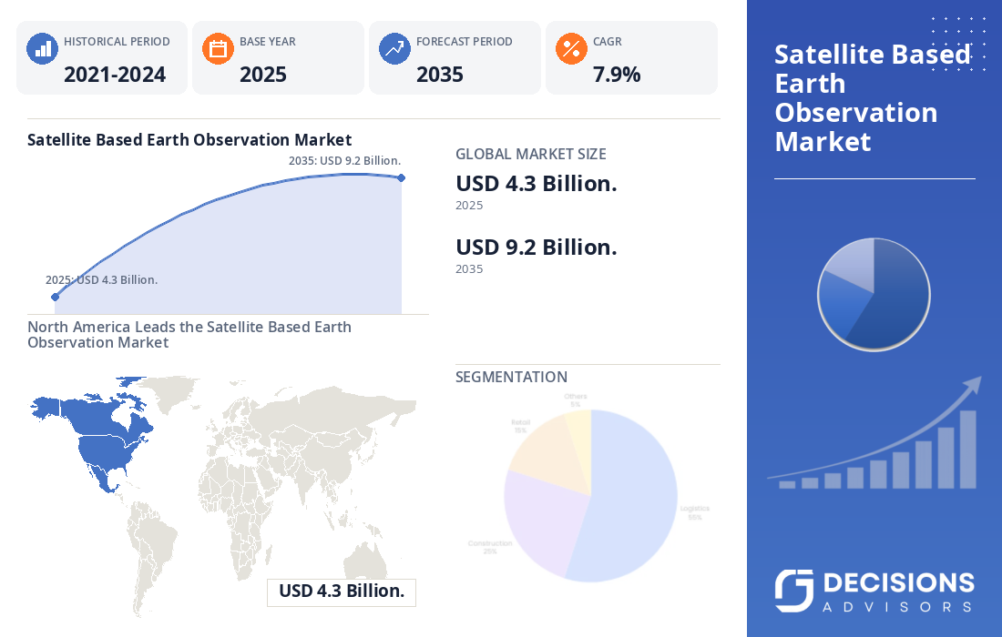
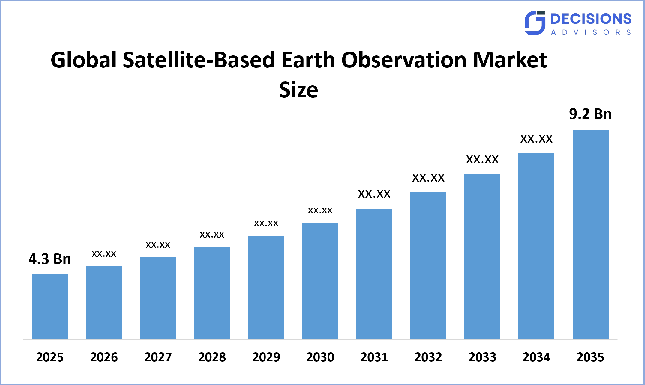
The Global Satellite-Based Earth Observation Market Size is predicted to grow from USD 4.3 Billion in 2025 and is likely to reach around USD 9.2 Billion by 2035 with a CAGR of 7.9%. According to Decision Advisors, a detailed research report on the market reflects that increasing demand for high-resolution, frequent, and near-real-time satellite imagery dominates the Global Satellite-Based Earth Observation Market, accounting for approximately 42% of the total share worldwide. Vantor (formerly Maxar Intelligence) remains one of the leading providers of high-resolution Earth observation capabilities, while Planet, Airbus, ICEYE, BlackSky, Capella Space, and other commercial operators continue expanding the competitive landscape.
Market Snapshot
- Global Satellite-Based Earth Observation Market Size (2025): USD 4.3 Billion.
- Projected Global Satellite-Based Earth Observation Market Size (2035): USD 9.2 Billion.
- Global Satellite-Based Earth Observation Market CAGR: 7.9%.
- Largest Regional Market: North America
- 2nd Largest Region: Asia-Pacific
- Fastest Growing Region: Asia-Pacific
- Base Year: 2025
- Historical Period: 2021-2024
- Market Forecast Period: 2026-2035
Market Overview/ Introduction
The global satellite-based earth observation market includes satellites, sensors, imagery, data products, tasking services, and analytical platforms used to observe and measure Earth's surface, atmosphere, oceans, infrastructure, and environmental conditions. Satellite-based Earth observation combines optical, multispectral, hyperspectral, thermal, and synthetic aperture radar technologies to provide information used across defense, agriculture, climate monitoring, disaster management, infrastructure development, maritime surveillance, forestry, mining, and urban planning. The industry is shifting from conventional government-led satellite missions toward a broader commercial ecosystem in which private operators provide frequently refreshed and taskable data to government and enterprise customers. Market growth is supported by satellite miniaturization, lower launch costs, larger satellite constellations, improved sensor resolution, cloud-based processing, and artificial intelligence-enabled analytics.
- United States, NASA's Commercial Satellite Data Acquisition program is expanding commercial access to high-resolution and frequent satellite observations for Earth science, environmental intelligence, disaster response, and public safety.
- Japan, Japan continues strengthening its Earth-observation capabilities through long-term national Earth observation planning, supporting climate, disaster, environmental, and security applications.
- Europe, European Earth observation demand is supported by Copernicus, national space programs, commercial SAR deployments, environmental regulation, climate monitoring, and growing demand for sovereign space-based intelligence.
Notable Insights: -
- North America is anticipated to hold approximately 30% share of the Global Satellite-Based Earth Observation Market over the predicted timeframe.
- Asia-Pacific is expected to grow at a rapid CAGR in the Global Satellite-Based Earth Observation Market, holding approximately 27% of the share during the forecast period.
- By Service Type, the Earth Observation Data segment dominated the market and holds approximately 51% share in 2025 and is projected to grow at a substantial CAGR during the forecast period.
- By Application, the Defense & Intelligence segment dominated the market and holds approximately 28% share in 2025 and is projected to grow at a substantial CAGR during the forecast period.
- The compound annual growth rate of the Global Satellite-Based Earth Observation Market is 7.9%.
- The market is likely to achieve a valuation of USD 9.2 Billion by 2035.
Market Drivers
The global satellite-based earth observation market is experiencing strong growth because governments and enterprises increasingly require accurate, frequent, and high-resolution geospatial information. Defense organizations are expanding the use of satellite imagery for intelligence, surveillance, border monitoring, maritime awareness, and infrastructure assessment. Agriculture companies are using satellite data for crop-health monitoring, precision farming, irrigation management, and land-use analysis, while energy and mining companies use imagery for asset monitoring and resource assessment. Environmental agencies increasingly depend on satellite observations to track deforestation, emissions, floods, wildfires, droughts, glaciers, and coastal changes. At the technology level, lower launch costs, small satellites, reusable launch systems, advanced sensors, AI-based image analytics, and cloud processing are improving the economics and usability of satellite-derived information.
Restrain
The market faces limitations associated with high satellite manufacturing and launch costs, complex ground infrastructure, spectrum requirements, and regulatory restrictions governing satellite data. Optical imaging can be affected by clouds, atmospheric conditions, and darkness, while high-resolution SAR systems require sophisticated hardware and processing capabilities.
Competitive Analysis:
The report offers the appropriate analysis of the key organizations/companies involved within the global satellite-based earth observation market, along with a comparative evaluation primarily based on their product offerings, business overviews, geographic presence, enterprise strategies, segment market share, and SWOT analysis. The report also provides an elaborative analysis focusing on the current news and developments of the companies, which includes product development, innovations, joint ventures, partnerships, mergers & acquisitions, strategic alliances, and others. This allows for the evaluation of the overall competition within the market.
Top Companies in the Global Satellite-Based Earth Observation Market
- Vantor
- Airbus Defence and Space
- Planet Labs PBC
- ICEYE
- BlackSky Technology
- Capella Space
- Spire Global
- Satellogic
- Thales Alenia Space
- ImageSat International.
Government Initiatives
|
Country |
Key Government Initiatives |
|
United States |
NASA's Commercial Satellite Data Acquisition program expands access to commercial Earth-observation datasets for scientific research, civil applications, environmental intelligence, disaster response, and public safety. The current On-Ramp 2 contract has a maximum cumulative value of USD 476 million |
|
Japan |
Japan continues supporting long-term Earth observation through national space and Earth-observation programs covering environmental monitoring, climate analysis, disaster management, and national security applications |
|
China |
China continues expanding remote-sensing satellite infrastructure and the use of satellite observations for agriculture, environmental monitoring, disaster management, mapping, natural-resource management, and national security |
Market Segmentation
The Global Satellite-Based Earth Observation Market share is classified into service type, application, and technology.
- The Earth Observation Data segment dominated the market and holds approximately 51% share in 2025 and is projected to grow at a substantial CAGR during the forecast period.
Based on Service Type, the Global Satellite-Based Earth Observation Market is divided into Earth Observation Data, Value-Added Services, Satellite Tasking & Monitoring, and Others. Among these, Earth Observation Data dominates the market and holds approximately 51% share in 2025. Demand for high-resolution imagery continues to increase across defense, agriculture, infrastructure, environmental monitoring, and disaster response. Commercial satellite operators are also improving revisit rates and data availability through large constellations. Increasing government procurement of commercial datasets is strengthening the underlying data segment, with NASA's 2026 commercial acquisition program providing a clear example of institutional demand.
- The Defense & Intelligence segment accounted for the largest share of approximately 28% in 2025 and is anticipated to grow at a significant CAGR during the forecast period.
Based on Application, the market is divided into Defense & Intelligence, Agriculture, Environmental Monitoring, Disaster Management, Urban Planning & Infrastructure, and Maritime Surveillance. Among these, Defense & Intelligence accounted for the largest share and holds approximately 28% share in 2025. Growing geopolitical uncertainty is increasing demand for persistent satellite-based intelligence and surveillance. High-resolution optical and SAR imagery provides governments with information on infrastructure, military assets, borders, maritime activity, and strategic locations. Commercial providers are increasingly supplementing government-owned satellite systems with rapidly taskable and frequently updated imagery.
- The Optical Imaging segment accounted for the largest share of approximately 40% in 2025 and is anticipated to grow at a significant CAGR during the forecast period.
Based on Technology, the market is divided into Optical Imaging, Synthetic Aperture Radar, Multispectral Imaging, and Hyperspectral & Thermal Imaging. Among these, Optical Imaging dominates the market and holds approximately 40% share in 2025. Optical satellite systems provide highly detailed visual information and remain widely used in mapping, defense, agriculture, infrastructure, and environmental applications. Improvements in satellite resolution and revisit rates are supporting broader commercial adoption. However, SAR is emerging as one of the fastest-growing technologies because it can operate during nighttime and through many cloud-cover conditions.
Regional Segment Analysis of the Global Satellite-Based Earth Observation Market
- North America (U.S., Canada, Mexico)?
- Europe (Germany, U.K., France, Italy, Spain, Netherlands, Rest of Europe).
- Asia-Pacific (China, Japan, India, Australia, South Korea, Rest of Asia-Pacific).
- South America (Brazil, Argentina, Rest of South America).
- Middle East & Africa (UAE, Saudi Arabia, South Africa, Rest of MEA).
North America is anticipated to hold approximately 30% share of the Global Satellite-Based Earth Observation Market over the predicted timeframe.
North America is anticipated to hold approximately 30% share of the global satellite-based earth observation market over the predicted timeframe. The region benefits from a mature aerospace and defense ecosystem, high government spending, established commercial satellite operators, and advanced geospatial analytics capabilities. The United States remains the dominant national contributor because of strong defense demand and commercial EO adoption. NASA's CSDA program is strengthening the commercial market by acquiring satellite data from multiple providers, including Airbus, ICEYE, Planet, ImageSat, and other companies.
Asia-Pacific is expected to grow at the fastest CAGR, holding approximately 27% share during the forecast period.
Asia-Pacific is expected to grow at the fastest CAGR, holding approximately 27% share during the forecast period. China, Japan, India, South Korea, and Australia are expanding satellite capabilities and increasing the use of EO data across defense, agriculture, disaster management, infrastructure, climate monitoring, and maritime surveillance. Large agricultural areas and frequent exposure to floods, cyclones, droughts, and other environmental events create significant demand for remote sensing. Increasing investment in domestic satellite manufacturing and launch capabilities is also improving regional capacity.
Europe is expected to hold approximately 23% share of the Global Satellite-Based Earth Observation Market during the forecast period.
Europe is expected to hold approximately 23% share of the Global Satellite-Based Earth Observation Market during the forecast period. The region benefits from Copernicus, national space programs, commercial satellite companies, and increasing demand for sovereign Earth intelligence. Environmental regulations and climate objectives are creating additional applications for land monitoring, emissions tracking, agriculture, forestry, and disaster management. Commercial SAR providers are also strengthening Europe's position; ICEYE launched four new SAR satellites in July 2026, bringing its successfully launched satellite count to 76.
Future Market Trends in Global Satellite-Based Earth Observation Market: -
-
- AI-Powered Earth Intelligence
AI is expected to become a core layer of Earth-observation platforms by automatically transforming satellite imagery into actionable intelligence. Machine-learning models can identify objects, detect changes, classify land, recognize infrastructure, and identify anomalies at significantly higher speeds than conventional manual analysis.
-
- Expansion of SAR Constellations
Synthetic Aperture Radar is expected to experience strong adoption because SAR can provide observations during nighttime and through many cloud-cover conditions. ICEYE's July 2026 launch of four additional satellites demonstrates continued investment in high-resolution commercial SAR capacity.
-
- Near-Real-Time Monitoring
Customers increasingly require frequent observations rather than occasional imagery. Large satellite constellations, automated tasking, high-speed downlink systems, and cloud-based processing are enabling more frequent monitoring of infrastructure, agriculture, shipping, disasters, and security-sensitive areas.
-
- Growth of Sovereign EO Capabilities
Governments are increasingly seeking independent access to satellite intelligence to reduce reliance on foreign data providers. Sovereign satellite constellations and public-private partnerships are therefore becoming important market opportunities
Recent Development
- In June 2026, NASA selected eight new commercial satellite data providers under its Commercial Satellite Data Acquisition program and expanded the range of commercial Earth-observation datasets available to researchers and government decision-makers.
- In July 2026, ICEYE successfully launched and deployed four new SAR satellites aboard SpaceX's Transporter-17 mission, bringing its successfully launched satellite count to 76.
- In June 2026, Portugal's CTI Aeroespacial signed a contract with ICEYE for two additional SAR satellite systems for the Portuguese Air Force, expanding its sovereign satellite capability.
Market Segment
This study forecasts revenue at global, regional, and country levels from 2021 to 2035. Decision Advisors has segmented the Global Satellite-Based Earth Observation Market based on the below-mentioned segment:
Global Satellite-Based Earth Observation Market, By Service Type.
- Earth Observation Data
- Value-Added Services
- Satellite Tasking & Monitoring
- Others.
Global Satellite-Based Earth Observation Market, By Application.
- Defense & Intelligence
- Agriculture
- Environmental Monitoring
- Disaster Management
- Urban Planning & Infrastructure
- Maritime Surveillance.
Global Satellite-Based Earth Observation Market, By Technology.
- Optical Imaging
- Synthetic Aperture Radar
- Multispectral Imaging
- Hyperspectral & Thermal Imaging.
Global Satellite-Based Earth Observation Market, By Regional Analysis.
- North America
- US
- Canada
- Mexico
- Europe
- Germany
- UK
- France
- Italy
- Spain
- Russia
- Rest of Europe
- Asia Pacific
- China
- Japan
- India
- South Korea
- Australia
- Rest of Asia Pacific
- South America
- Brazil
- Argentina
- Rest of South America
- Middle East & Africa
- UAE
- Saudi Arabia
- Qatar
- South Africa
- Rest of the Middle East & Africa
Frequently Asked Questions (FAQ)
Q. What is driving the growth of the Global Satellite-Based Earth Observation Market?
A. Increasing demand for high-resolution imagery, defense intelligence, climate monitoring, precision agriculture, disaster management, infrastructure monitoring, and maritime surveillance is driving market growth. Lower satellite launch costs, larger constellations, AI-based analytics, and improved sensors are further expanding applications.
Q. Why is Synthetic Aperture Radar becoming important in satellite-based Earth observation?
A. SAR can capture observations during both daytime and nighttime and can operate through many cloud-cover conditions. This makes it highly valuable for defense, disaster response, maritime surveillance, infrastructure monitoring, and environmental applications requiring persistent observation.
Q. How is artificial intelligence transforming satellite-based Earth observation?
A. AI enables automated object detection, change detection, land classification, anomaly identification, and predictive analysis across massive satellite datasets. This reduces processing time and allows organizations to convert raw imagery into actionable intelligence more efficiently.
Q. Which region is expected to grow fastest in the Global Satellite-Based Earth Observation Market?
A. Asia-Pacific is expected to record the fastest growth during the forecast period, supported by increasing satellite investments, defense requirements, environmental monitoring, agricultural applications, disaster management, and expanding commercial space capabilities.
Check Licence
Choose the plan that fits you best: Single User, Multi-User, or Enterprise solutions tailored for your needs.
We Have You Covered
- 24/7 Analyst Support
- Clients Across the Globe
- Tailored Insights
- Technology Tracking
- Competitive Intelligence
- Custom Research
- Syndicated Market Studies
- Market Overview
- Market Segmentation
- Growth Drivers
- Market Opportunities
- Regulatory Insights
- Innovation & Sustainability
Report Details
| Scope | Global |
| Pages | 220 |
| Delivery | PDF & Excel via Email |
| Language | English |
| Release | Aug 2026 |
| Access | Download from this page |